Showing posts with label maps. Show all posts

April 23, 2016

This Week in Noe Valley: High End Homes Languish, More Bar Robberies & Fires, Gentrification 1977 Style


The latest news from, about and for Noe Valley from around the interwebs:
[Photo: Bougainvillea doorway via Beyond Ordinary]

August 29, 2015

This Week In Noe Valley: La Bou Closing Soon, The Root Wants You To Re-Wild And Local Blight From 1945


News from, about and for Noe Valley from around the interwebs:
[Photo: Noe Valley summer day via daretoeatapeach]

February 14, 2015

This Week In Noe Valley: RadioShack Spared, Fun With SF Maps, And An Extreme Valentine


News from, about and for Noe Valley from around the interwebs:
[Photo: Cherry blossoms via chloeiot]

May 28, 2013

Noe Valley Power Outages


Neighbors have reported multiple power outages in Noe Valley over the last month. We're curious: is the power going out more often than the historical norm or does Twitter magnify small outages? Here are examples of some Tweets from the last few days:


PG&E tracks current outages, but as far as we can tell doesn't make public data on power outage trends by neighborhood. So we're asking for your input - send us reports of power out within Noe Valley via email or Twitter and we'll map all data. Maybe there's a trend we can talk to PG&E about.

[NVSF: Map of Noe Valley Power Outages]
[PG&E: Outage Map]

September 23, 2012

A Most Excellent Map Of Employee Shuttle Bus Stops


No routes have been published of employee shuttle bus stops, but Realtors seem to know where they are - they're a huge bonus for selling or renting property in Noe Valley and other neighborhoods to those commuting to Silicon Valley. Neighbors have loved/hated them since around 2008. The City conducted a study concluding there's money to be made in regulation. But no one has quantified what everyone wants to know - how many people ride them and do they do more harm than good?

Data visualization experts at Stamen Design were commissioned by Zero1 to study how many people make the commute from San Francisco to the Silicon Valley, urban to suburban. It was a long process, and the above map was created. The nut? Besides the really cool graphic? "At a rough estimate, these shuttles transport about 40% of the amount of passengers Caltrain moves each day. Google alone runs about 125 trips daily, all over the city."

[Stamen: The City from the Valley (2012)]
[Zero1 Biennial]

May 29, 2009

Where Is Noe Valley *Really*?


With all the geeks/programmers/engineers/coders in San Francisco you'd think someone would have come up with a better map of San Francisco neighborhoods than realtors provide. Enter the The Neighborhood Project --they cull data from Craigslist housing posts and input on their own site to map out how people identify where they live. Call it democracy in mapping.

Check it out. If enough people help populate the map we may have to change the borders we use to cover Noe Valley.

[The Neighborhood Project (via Curbed SF)]
[SFGate: Familiar S.F. neighborhoods gain new names]
[NVSF: Fun With Maps: Where is Noe Valley?]

October 28, 2008

Noe Valley is Liberal

Fall Line Analytics (via Sweet Melissa) has compiled voter data (and probably more info than anyone really wants to know) about you and everyone you know.

It's no surprise that Noe Valley is mostly liberal, a little moderate and maybe just a tad conservative. Cool map, but it just enforces what a commenter on TheFrontSteps said about life here: "The people in Noe Valley simply have a fully realized liberal fantasy. The ‘charm’ of a tightly controlled social environment, while being near all of those other parts of the city that they can’t quite bear to give up…" But we knew that.

As an aside... if this map is truly accurate how did Chris Daly get elected? Twice!?

[Sweet Melissa: Off To The Races!]
[TheFrontSteps: Comment Du Jour...]

September 16, 2008

Fun With Maps: Where is Noe Valley?

SF MLS District 5C
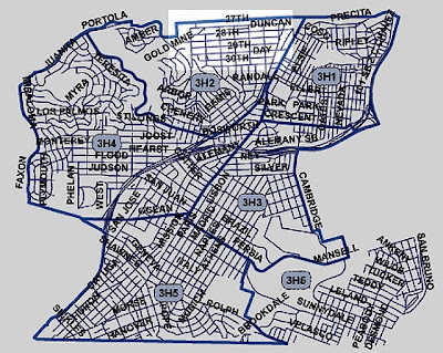
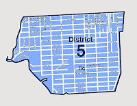
Defining the borders of Noe Valley can be difficult, if not futile. Because of this we've decided to use the realtor map that defines District 5C. On our recent walk around the perimeter we were joking about "Noe" and "Not Noe" when looking at houses on the same street, and other times we felt like we were in entirely different neighborhoods. Take, for example, Diamond Heights Blvd: technically Noe Valley, but 24th St is not convenient for services. This map may be arbitrary, but it's what we'll use to define Noe Valley.

Here are some other maps that serve our neighborhood, with District 5C highlighted on each map.


Supervisor District 8
Supervisor District 8.


Zip Code Map
Zip Code Map


SFPD Mission Station


SFPD Ingleside Station